Let's ask a hydrogeologist!
I recently had the opportunity to sit down with Timothy Parker of Parker Groundwater Consulting in Sacramento, CA.
Timothy Parker began his career as a regulator working in contaminant hydrogeology. He got involved with fresh water while working for the California Geological Survey, doing watershed assessment and timber harvest oversight, and for Department of Water Resources, providing assistance to local agencies on groundwater and conjunctive management projects. He also worked in the oil industry applying advanced oilfield technologies to groundwater management.
Since 2009, Tim has worked as an independent hydrogeological consultant. In 2021, he also took a part time job with Ramboll Engineering Solutions America as the professional geologist on the statewide airborne electromagnetic surveys that are being used to map aquifer frameworks, specifically those basins under the Statewide Groundwater Management Act (SGMA).
Loni Lyttle: So, I wanted to talk to you today about groundwater recharge. California, along with the rest of the western United States has been in a long drought and is facing serious issues with groundwater depletion not to mention subsidence, where the land is actually sinking due to overdrafting the aquifer. But then we get these two wet years in 2023 and 2024 (so far) with above average rainfall. I think this lulls people into a sense of security about California’s water situation and I’m not sure it’s that simple. I’m not a hydrogeologist so I wanted to get in touch with someone who knows more on the subject.
Tim Parker: You are right – the surface water reservoir drought is over but our groundwater reservoirs are still in drought conditions. So there’s a lot of recharge going on and we don’t always know how successful it is and whether or not it’s causing potentially adverse impacts. And I hate to start off on that point, but it is something we have to be concerned about.
There’s a lot of good information out there. Just in the last few years, the state has started putting a lot more information out on groundwater level information, including changes over a year that you can see visually.
One of the things in my research that I was surprised about was on subsidence in the Central Valley. We’re aware of the subsidence there. But when you look at the change in subsidence that’s being monitored on an annual basis, the change during those wetter years was much less. I thought that was pretty interesting because there is a significant lag time with subsidence. Once you have subsidence and you shut the pumping off, It doesn’t just stop altogether. It continues to subside for some period of time.
LL: That is interesting. I mean when I think of subsidence, I think immediately of the Central Valley just because I know it’s so severe. I mean the water that people are pumping there is ancient water, right? That basin filled up a long time ago?
TP: Yes and no. One of the things we found with the statewide aerial electromagnetic project is the way the sediments were deposited in the Central Valley, especially the San Joaquin Valley. So during the Pleistocene you had periodic glaciers, lots of ice and then melts. That action created these incised alluvial fans. (read more about this topic here.)
So that’s very coarse grain sediments coming off of the Sierra Nevada mountains. And actually Stanford’s done some work tracking subsidence data, groundwater levels, and precipitation. Through that you can see the water coming into the basin especially along those kind of superhighways for recharge coming off of the mountains. Now that’s fresh, young water coming in. But you’re right, most of the deeper water being pumped is old. Back in the 60s, there were some studies done and found that groundwater levels have dropped several hundred feet. And again, that’s where we are today. Groundwater levels have have continued dropping significantly, and that means you’re getting some recharge of fresher, younger water up on top, the pumping is mostly deeper, typically where the groundwater gets older.
Parts of the San Joaquin Valley has huge problems with depletion and associated subsidence. The economic impacts are big in these situations.
LL: So in the San Joaquin Valley for instance, how many years of water do they have left if they continue to pump as they have been?
TP: I haven’t looked into that. I do know it’s dropped several hundred feet over the decades. It’s about a 2 million acre-feet overdraft per year. That’s one of the estimates that’s out there. If pumping continues at the current rate, the basin has a limited lifetime, whether that’s a few decades or many decades.
The other issue in all of that is water quality. The deeper you go, you’re going to run into higher total dissolved solids in addition to the problem of land subsidence. Subsidence is a big economic driver because it affects infrastructure. The Central Valley and the state as a whole relies on moving water from where there’s more precipitation in the north to where there’s much less precipitation in the south. And these aqueducts and irrigation ditches, et cetera, are gravity drains. When the land sinks, that interrupts the flow, and so they’re having to do a lot of repairs. The other thing is that you have floods in different areas where you didn’t before. So that’s another risk and liability.
LL: So can you go more into where our groundwater comes from? How variable is groundwater within a given region or even within a given basin? I’ve seen it where we are. Even within Paso Robles, there’s so much variation. You have eastern Paso, which looks like an old western movie, but then the water is really good. There are good wells out there where you hit water at less than 100ft. Then growers in western Paso have to get their water out of fractured rock and it’s barely a trickle.
TP: It has to do with the geology and California has a very interesting geology. It was formed by tectonic plates pushing against one another. That formed the Central Valley as a structure. One plate underneath the ocean (oceanic plate) was subducted underneath the continental plate. That caused the subducted plate to melt and form the Sierra Nevadas. The Central Valley was what they call a forearc basin, where sediments were formed as part of an inland sea. And then marine sediments that were on top of the ocean plate were scraped up and formed into the coastal ranges. So you have these marine sandstone shales all folded up and deformed. And that’s the bedrock that you’re talking about in the Paso area on the west. And then the other thing that happened 20 to 30 million years ago, was that subduction zone changed to a transform fault, which you probably know the name of…the San Andreas fault. When that happened, there was this sort of northwest structural, tensional and extensional change that occurred.
As a result of the transition to San Andreas transform fault tectonics, you have all these northwest trending small basins in the coast ranges that are faulted as a result. And those filled with alluvium or sand, silt and gravel. And so those are the kind of the two types of basins you’re talking about. In the coast ranges, it’s typically more limited unconsolidated alluvial deposits, and fractured bedrock that doesn’t produce much water. It’s okay for a residence where you need five to ten gallons per minute. And then in the alluvial systems, you get a lot better production, typically. But anyway, that’s kind of the difference in that is whether you’ve got an alluvial aquifer or bedrock aquifer that you’re getting water from.
LL: These small coastal basins, is that what we have in northern California wine country. Are Sonoma and Napa in those little coastal basin areas?
TP: There’s so much diversity up there. I’ve actually worked in the Sonoma Valley for almost 20 years as a groundwater management consultant. Sonoma is one of the more complex basins because you have also volcanics and multiple faults there. What we like to say is that it’s “compartmentalized”. It’s got all these separate compartments. You can drill a well in the Sonoma Valley and move 25ft over and you might get water in one and nothing in the other. That’s how quickly things can change. It’s very complicated geology. The San Andreas is a fault zone that’s several miles wide. Then there’s a lot of other faults that are the same trend that run through these coastal basins. And then you have other faults that run to 90 degrees to that. So there’s all this different movement that’s occurring, and that’s what makes the hydrogeology complex. Some of those faults can be conduits and a lot of them can be barriers, so you can move from one side of a fault to another and get completely different geology and groundwater results.
LL: That is something I found interesting when I was reviewing some of the literature. I didn’t realize just how much faults play a role in groundwater. And I think a lot of people think a basin is shaped like, as the name implies, a basin. Isn’t it just a big bowl or a bathtub? But it’s so much about just underground tectonics. What is it about a fault that makes it a conduit versus a barrier?
TP: Well, it depends on kind of a movement on it and what material is in it. So if it’s got a lot of clay or fault gouge, that would tend to make it a barrier. It also depends on whether it’s extensional or tensional. So whether it’s pushed together or kind of pulling apart. It also depends on whether or not it offsets the layers of sediment. So you can have sort of fine grain layers that come from lake bed deposits and floodplain deposits. And then you can have coarser deposits, channel deposits associated with sands and gravels. And so those can get offset. You can offset a clay against a very coarse grain unit, for example, and that can cause a barrier.
One thing about alluvial aquifers is that they are very heterogeneous. In other words, they’re not just big bowls of sand. They’re typically a lot of clay. For example, the Central Valley is more than 50% clay. And so you then have these channels that are not necessarily connected and different types of deposits within it.
LL: It’s interesting you say that. A lot of what we do with soil moisture is looking at how water percolates. We’ve noticed that if you have an abrupt change in soil texture, it’s like the water just doesn’t go past it even if it’s a heavier soil on top of a sandier one. It’s kind of counterintuitive.
TP: Yeah, the water will follow the path of least resistance.
LL: So I wanted to go into how water behaves underground. So what are some other things that might create an aquitard (ie. a barrier to percolation)? I mean, we talked about fault lines. What sort of situations can stop water from moving from surface and subsurface into the aquifer?
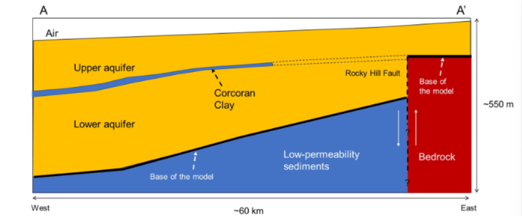
TP: Well, yeah, typically they’re lacustrine or lake, or floodplain deposits. A great example is down in the southern portion of the San Joaquin Valley where the Corcoran clay occurs. That’s a pretty thick lake bed deposit. It’s definitely what you would call an aquitard. Aquitards, aren’t completely impermeable though. Water does move through them, but it’s at a much slower pace. Desert geology, especially playas also have layers of caliche that can be 1 to 3 feet thick, which is basically calcium carbonate that has been dissolved by water at the surface and preciptates in the subsurface like a cement that binds the shallow soil materials together.
Some older sediments, too, that become consolidated and cemented can also act as aquitards. So it depends on how old it is, how deeply buried things are and how cemented. As you get deeper into the subsurface, the system becomes compacted and transmits less water, typically.
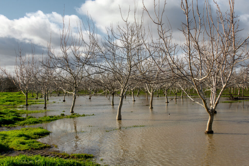
LL: So we’ve had a lot of rain in the last two years. Where has most of that water gone? Does that stormwater get into the aquifer? Does most of it end up kind of just washing out?
TP: Well, it depends. That’s one of the things that we’re challenged with in the state, and everybody in the water industry is really working on. Right now we don’t have the infrastructure to put as much of that water into the ground as is possible. So we are sending a lot out to the ocean still. There are also regulations that are in place to protect the environment and ecosystems that tend to be in conflict with what we would like to do with recharge, because the facilities we have statewide were built based on hydrology from 100 years ago when the climate was wetter.
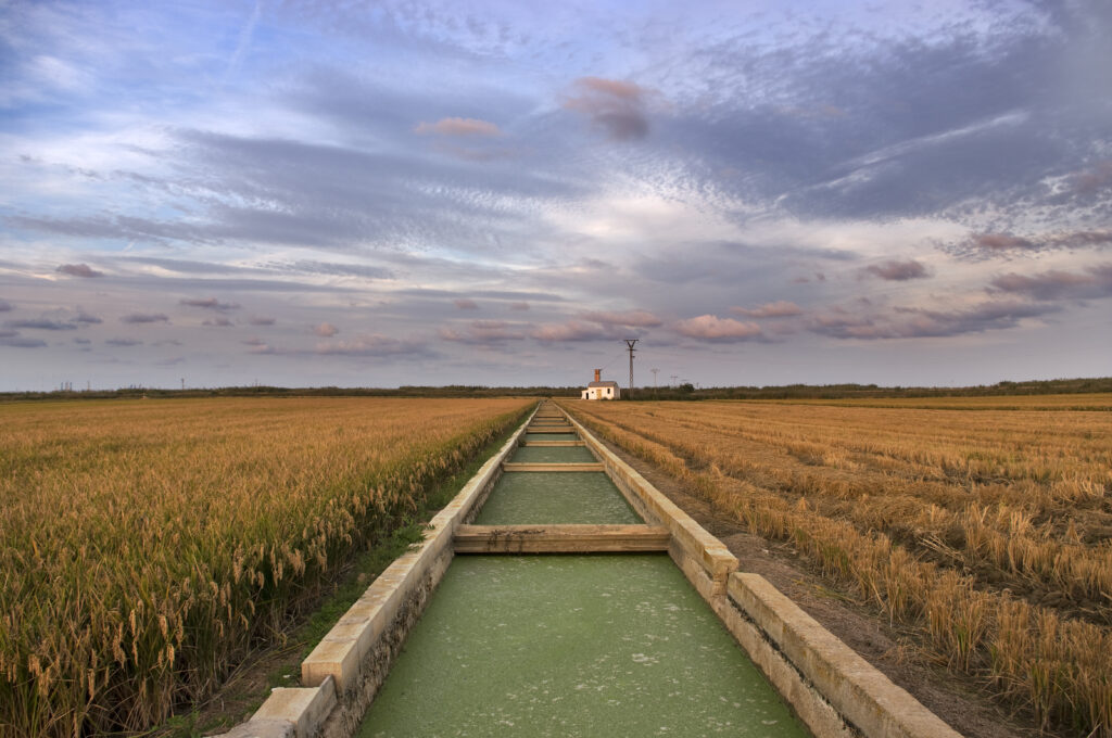
Right now, especially in the San Joaquin Valley, there’s a lot of movement to do on-farm recharge. And I know also in the wine country, there’s quite a bit of work going on with on-farm recharge. That all will depend on how much water can you apply and not damage the vines, which are a huge investment. It also depends on how much can you put in the ground in those situations and protect the water quality.
It takes the facilities to do that, because when you have dry years, for a number of years, the soils get dry. In those cases there tends to be more runoff than infiltration. You’ll lose more water initially. You need to have a pretty long wet season, or else a few wet seasons in a row to really get a higher level of infiltration. We’ve gotten so good at taking water out of the ground. Now we’re just working on ways to try to get better at putting that water back in the ground.
LL: When you talk about on farm methods, do you mean just flooding farmland?
TP: Yeah, it’s a huge movement and it’s being led by the Department of Water Resources and some really innovative land stewards, I would call them. They’re actually farmers. You’ve also got folks like Sustainable Conservation and universities like UC Davis doing research and looking at the potential for water quality impacts, because a lot of these agricultural soils have a lot of nitrates in them. You don’t want to flush those into the groundwater. The term being used is FloodMAR.
It’s an evolving process, but there’s a lot of progress been made. There was a huge amount of water that was recharged the last year that wasn’t the year before. So we’re really encouraged with it. Part of the philosophy there is you should try to put the water back in the ground where you’ve taken it out. And that makes sense. We need to monitor it for levels and quality to make sure that it’s getting down to the aquifers and it’s not causing any degradation. And so far, it looks pretty promising.
LL: Just for clarification, when they’re talking about flooding, they just mean using fresh rainwater, right?
TP: Yes. Yeah, it’s with flood flows. That’s the key word.
They’re carving off the upper 5% to 10% off of the flood flows. That’s the other challenging aspect: water rights. You can’t impact somebody else’s water rights by taking water. There’s a whole complicated permitting process that you have to go through. The state’s really working on making that more efficient because you can’t have a process that takes so long that you miss the storm. You have to have a planning process in place up front to catch those flood flows.
LL: In regards to using farmland for recharge, does that only really work when it comes to rainfall and therefore saturated soils? We see a lot with the overapplication of drip irrigation and sprinkler application in the case of frost protection. In this case, the rest of the profile is dry. Does this water get into the aquifer eventually or does it get caught up in subsurface flow?
TP: Most of the recharge in the San Joaquin Valley comes from over irrigation of farmlands. And yes you can have recharge occur if over irrigating with drip irrigation systems. Once the moisture content of the soil exceeds the field capacity, water will move downward and may become recharge, dependent upon the geology and distance. If you have geologic materials that are low permeability i.e., aquitards, the water may not make it into a viable aquifer, and if you have a very deep unsaturated zone (several hundred feet thick), it may not make it that far.
LL: I’ve also heard of people recharging stream beds. I guess a stream bed is also a good recharge zone, usually?
TP: Yeah. If you look at Orange County, they’ve developed recharge down there into a science. They’ve done so many studies, and they have these facilities with little berms around them that create these recharge areas right along the Santa Ana river. They reduce the amount of silt in the water through some innovative processes. And then they just let water in when the storm flows come in. They also are recharging the base flow of the Santa Ana river, which is about a 90% tertiary treated wastewater upstream, which is a pretty interesting thing as well.
LL: I’ve heard of people trying to do that also with reclaimed water, but at its face sounds icky. Is there an environmental risk factor there?
TP: There’s a lot of that going on. It’s not as much in northern California. In the LA Basin, Orange county, and San Diego, they’ve all had to do that sort of thing for decades because they just have been relying on imported water. Imported water has become less reliable from the State Water Project and the Central Valley Project because of the swings in dry years and wet years. They’ve had to do a lot more recycling, and they are using advanced treatment to both infiltrate and inject water into their aquifers. They’re also using the tertiary treated water along the Santa Ana river. We’re just going to see more and more of that as time goes on. For more info, take a look at these projects in Southern California:
- The Orange County Water District Groundwater Replenishment System
- WRD’s Win 4 All
- Pure Water San Diego
The aquifers do help treat things like viruses and bacteria. The longer it stays in there and travels, you see what they call log reductions in the amount of virus and bacteria.
LL: So what is your message for the future?
TP: Well what we’ve seen over the last year and previous decade is that we’re in a time of extreme events. We’re going to get a series of dry years, then we may get one or two really wet years. We just have to change our thinking from, “let’s recharge when the water is available” to just, “let’s recharge whenever we can”. Like I said earlier, we’ve gotten so good at taking water out of the ground, so we need to do everything we can to put it back in the ground. That can mean big capital projects or even changes to urban settings where you reduce hardscapes and focus on improving infiltration.
Historically, we’ve just been flushing wastewater into the rivers and it isn’t always treated well enough. We need to tackle two things. We’re need to reduce the amount of waste that we’re putting into our stream flows and into the ocean, and also better use that water and put it into application. So that’s really what it’s all about to me, is we’ve got to do more recharge and we’re getting there.
The state’s working on it. The federal government’s aware of it, and all these local agencies are working really hard, along with landowners to try to make some progress in this area.
LL: That’s hopeful. Tim, Thanks so much for sitting down with me.
TP: You’re welcome and thanks for the opportunity.
Citations:
Kang, S., Knight, R., & Goebel, M. (2022). Improved imaging of the large-scale structure of a groundwater system with airborne electromagnetic data. Water Resources Research, 58, e2021WR031439. https://doi.org/10.1029/2021WR031439